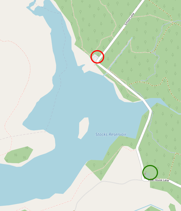
As Britain’s population grew throughout the 19th Century and the demand for water in its towns and cities increased, local authorities and water boards looked to rural areas, building dams in remote valleys and creating large reservoirs. The Stocks Reservoir, completed in the 1930s, is one such reservoir, located in Dalehead in the Forest of Bowland in north west England. The reservoir takes its name from the village of Stocks-in-Bowland, most of which now lies beneath the flooded valley. The village church of St James, however, was dismantled and reconstructed on higher ground and the occupants of its churchyard moved to a new burial ground. What intrigued me most about this peaceful little burial ground is that many of its burials have taken place in the years since the Stocks Reservoir was built and the local population displaced. The nearest villages are all a few miles away, with only a few scattered farms in between, but the families of those with links to Dalehead and Stocks-in-Bowland have continued to bury their dead here, nearly a century after the valley was drowned by the reservoir.
The Stocks Reservoir is very remote, accessible only by small, winding roads, a long way from any towns or cities. Until 1974 this area was part of the West Riding of Yorkshire, but the reorganisation of local government and county boundaries in that year brought it into Lancashire. The reservoir sits within the Forest of Bowland Area of Outstanding Natural Beauty, “an outstanding landscape whose distinctive character and natural beauty are so precious that it is safeguarded in the national interest.” It covers over 300 square miles of land, with some dramatic scenery and important habitats for rare creatures, including the hen harrier. Parts of Bowland experience high levels of rainfall, and as a result many of its rivers are integral to the water supply for the north-west of England.

Historically, Dalehead was home to a sparsely-populated farming community, with a few local facilities such as a smithy, post office, inn and reading room at Stocks. Completed in 1852, St James’ Church was a relatively late addition to Stocks – previously, locals would have faced a long journey to the parish church in Slaidburn. Dalehead became a parish in its own right in 1871, though not all of its vicars remained in post for very long – such an isolated parish would have come with its own challenges.

1910 Ordnance Survery Six-inch map of Yorkshire CXLVIII.SW, shared under a Creative Commons Licence (source)
Plans to build a reservoir in this area began in the early 20th Century, when the Fylde Water Board (which served Blackpool and the other towns on the Fylde Coast) secured an Act of Parliament that authorised them to buy up land in the valley. Farms and other buildings were demolished, and their former inhabitants moved away. Locals had little choice in the matter – the water board’s money for compulsory purchases and the solicitors at their disposal meant that even those who did not wish to leave the area were compelled to sell up and leave.
However, as the communities of Dalehead and Stocks-in-Bowland were scattered as their homes were bought by the water board, a new temporary village began to take shape to house the workers who would construct the new reservoir. Hollins village housed several hundred workers and their families, and had facilities such as a small hospital and a cinema as well as the various engine sheds and workshops required to support the building work. A temporary light railway, using rolling stock left redundant after the First World War, was also constructed to support the construction of the reservoir.
By the late 1920s, work was underway to build a dam and construct the infrastructure needed to supply the Fylde coast with Dalehead water – finally, in 1932, the dam across the River Hodder was completed and by early 1933 the valley had been flooded to create the Stocks Reservoir.
Although the church of St James was not set to be submerged by the Stocks Reservoir, plans were made to demolish it and move the occupants of its churchyard to higher ground. The site for a new burial ground was prepared in 1926 and the first person to be buried there after its consecration was a 15-year-old girl who died at Hollins village. She was buried at the end of November 1926, a few weeks after the site had been consecrated by the Bishop of Bradford. I could not find a headstone that correlated with this date and the age of the girl, so it appears that her grave is unmarked.
In 1927, exhumation of the old churchyard began. The exhumations took place between midnight and 4am, and in total around 150 bodies were carefully and respectfully disinterred and reburied in the new burial ground. Wherever possible, headstones were relocated to mark the new grave locations of the people they commemorated.


Some of the bodies could not be individually identified – likely those buried in graves that did not have headstones – and were instead reinterred in a mass grave at the new site with a special memorial marking the site.


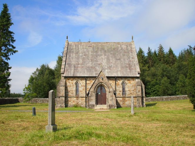
St James’ Church continued to be used until 1936, with its last service before demolition taking place on 24th May of that year. As the people of Dalehead were moving away, a church for regular worship was no longer needed but local people expressed a wish to continue using the new burial ground, and the decision was made to rebuild the old church as a mortuary chapel at the new burial ground. The church was carefully dismantled and its fabric was used to construct a smaller building with the same Gothic features as its predecessor.


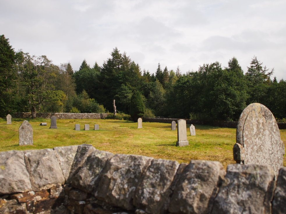
I visited Dalehead on a warm August afternoon, and found the graveyard empty apart from a couple who were sitting in the shade of the chapel walls, eating their packed lunch. Most of the people who passed the burial ground didn’t come in; a couple of lads cycling past speculated on whether it was bikers who got killed on the remote roads who were buried here, in this unexpected spot so far from any houses. I was thirsty after the long drive from Preston, and settled down in the shade of a tree to relax for a while. It was incredibly peaceful, with only the soft whir of the nearby wind turbine and the occasional call of a buzzard for company.

The original site of St James’ church can now be seen close to one of the car parks close to the reservoir. The church’s foundations, previously not visible above ground, were exacvated in 2011-12 by a community archaeology project that involved many local people. This project aimed to engage with the history of Dalehead and the community that once lived there. Although photographs and plans of the old church survive, so we already know what it looked like, excavating its foundations and preserving them for display means that the site of the old church is now visible to users of the large car park which surrounds the ruins, and allows visitors a glimpse of what Dalehead was like before the reservoir was constructed. An information board provides a brief history of the church and why it was demolished, as well as labelling different features of the ruins and describing the archaeology project which uncovered the church.


Set into the walls close to the old church’s foundations are a number of date stones from buildings which formerly stood in Stocks and Dalehead, the oldest of which date back to the 17th Century. An information board, installed at the same time as the one describing the church’s ruins, places these stones in context as some of the last tangible remains of the homes and businesses that once made up this rural community.


As it’s such a remote burial ground, Dalehead is little used, but it is well looked after and burials of those with links to the area have continued since the 1930s. Mark Etheridge, who has published a wonderful website exploring his family history, has carried out a survey of the gravestones at Dalehead and this shows that a number of families are represented in burials from both before and after the burial ground was relocated.


Today, the Stocks Reservoir and the adjacent Gisburn Forest are managed by United Utilities. The reservoir continues its original role as a supplier of water to north-west England, and has also become a popular angling location and attraction for day trippers, drawing visitors from around Lancashire and Yorkshire. Gisburn Forest is home to many footpaths and cycling trails, while the reservoir itself is celebrated for its wildlife – dozens of species of wildfowl can be seen and even the occasional osprey has been sighted.

The little burial ground at the corner of Hole House Lane is a beautiful and tranquil spot in its own right, but it also serves as an important memorial to the people of Dalehead and the community which once made this valley their home.
I visited Dalehead Churchyard in August 2020.


References and further reading
Dalehead and Stocks in Bowland and the construction of the Stocks Reservoir – a wonderful collection of old photographs and recollections of Stocks and Dalehead
Stocks in Bowland (Dalehead), St James – Family history of Mark Etheridge, 2018
Nazia Parveen – “Archaeological dig evokes memories of Stocks-in-Bowland community replaced by reservoir,” Lancashire Evening Telegraph, 3rd January 2012
St James’ Church, Stocks-in-Bowland – Interim Historical Study, Oxford Archaeology North, April 2012 (PDF)

Caroline, thanks as usual for a fascinating introduction to this interesting location. I love visiting these places with you and learning about the people and the history.
(From Kansas City, MO in USA)
LikeLike
Thank you!
LikeLiked by 1 person
Beautiful photos and an interesting story. I think you mean “carefully dismantled” rather than “demolished”.
LikeLiked by 1 person
Thank you! I read through the article dozens of times before hitting publish, but that phrase was one that slipped through the net.
LikeLike
It is so interesting to learn of little burial place pockets throughout England. Thank you for taking us along with you on your quest to learn about this area’s history. I’d love to take some walks in that area as you made it sound so peaceful. Who doesn’t need a little peace in their everyday lives? Thanks, Caroline, your articles are always something I eagerly anticipate.
LikeLiked by 1 person
Thank you so much Twila! Dalehead is an incredibly peaceful and beautiful place – although I know parts of the Forest of Bowland well, as I grew up not too far away, I had never been to Dalehead until I went in search of the old graveyard, and I’m very glad I made the journey.
LikeLike
Caroline,
Thanks for the excellent history and pictures.
I plan to visit the church (again) tomorrow and your comments have inspired me. Not too arduous a journey, as I live in Clitheroe.
LikeLike